سحب تيارات الحمل هي غيوم تنشأ عبر الحمل الحراري لذلك تم إطلاق هذا الأسم عليها
الحمل الحراري الناتج عن تسخين رقعة من سطح الأرض عبر فرط الإشعاع الشمسي التسخين اللذي تحدثه الشمس على البر في فترة النهار خاصة الظهيرة هو اللذي يعمل على تشكل الحمل الحراري
هذا الحمل الحراري يصعد نحو الأعلى بإتجاه طبقات الجو العليا بشكل متسارع إن من خصائص الهواء الساخن أنه اخف وزنا من الهواء البارد لذلك يصعد بسهولة نحو الأعلى
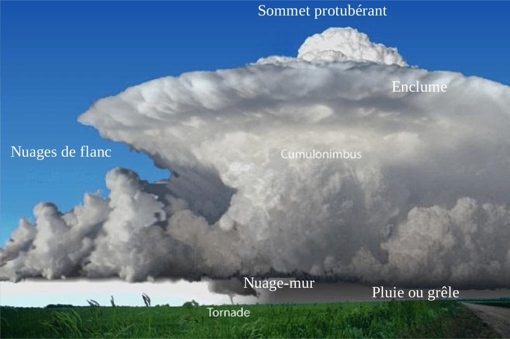
أثناء صعود الهواء بسبب التسخين المركز يبدأ في رفع الرطوبة معه في طريق صعوده وعندما يصل الهواء إلى ارتفاع معين يزيد في الغالب عن 2 كيلومتر يبدأ يتحول إلى غيوم ركامية متفرقة تبدأ هذه الغيوم في النمو تكون في أول الأمر صغيرة مبعثرة فوق البر بعيدا عن الساحل هذه الغيوم تزداد في الحجم مع استمرار التسخين على سطح الأرض يحمل الهواء الساخن المتجه بإستمرار نحو الأعلى المزيد من الرطوبة وعند وصولها للغيوم يستمر النمو لسعات وساعات قد يستمر النمو مدة تصل 3 ساعات
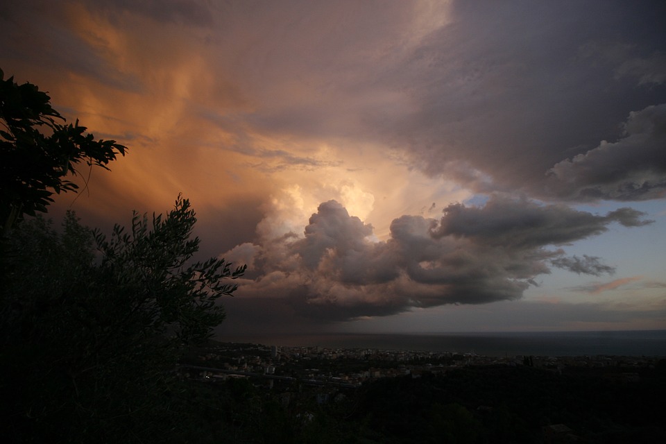
وبعد أن تتحصل الغيوم على تغذية كافية يزداد حجمها وتبدأ تلتحم مع بعضها البعض لتشكل مركز أو مركزين أو أكثر وتصبح على شكل قمم عالية يتم مشاهدتها عن بعد واضحة لكن إذا كنت تحتها مباشرة لا يمكنك رؤيتها بشكلها الكامل إنما تشاهد فقط قاعدتها
يمكنك زيارة حالة الطقس للتعرف عن الحالة الجوية http://Facebook.com/tages555toha
غيوم الحمل تنمو لتصل ارتفاعتها حتى 10 كيلومتر في بعض الحالات خاصة في المناطق المدارية وعلى خط الإستواء
تنمو أيضا غيوم الحمل في المنطقة العربية خاصة في فصل الخريف والربيع
سحب تيارات الحمل من أكثر الغيوم انتاجا للعواصف الرعدية العنيفة عبر التصادم الحاصل داخلها بين حبات البرد الكبيرة عندما يبدأ الهواء في التجمد في قمم هذه الغيوم
يهبط الهواء البارد من أعلى غيوم تيارات الحمل بعد وصولها لإرتفاعات شاهقة مما يعمل على انخفاض درجة حرارته مع مرور الوقت ويبدأ وزنه يزداد مما يجبره على النزول بقوة حاملا المطر والرياح العاصفة
Pulling load currents are clouds created through convection so this name is released
Thermal convection caused by heating a patch of the surface of the earth through excessive solar radiation The heating of the sun on land during the day, especially the afternoon is the work on the form of convection
This convection rises up toward the upper atmosphere in an accelerated manner. The characteristics of hot air are lighter than cold air so it easily rises to the top
During the rise of the air due to the heating center begins to raise the humidity with it in the way of the rise and when the air reaches a certain height is often more than 2 km begins to turn into clouds Cumulus clouds begin to grow clouds are initially small scattered over the mainland away from the coast These clouds Increase in volume As the heating continues on the surface of the earth carries the hot air constantly moving to the top more moisture and when it reaches the clouds continue to grow the stings and hours may continue to grow for up to 3 hours
Once the clouds get sufficient nourishment and increase in size and start to combine with each other to form a center or two centers or more and become in the form of high peaks are visible distance, but if you are directly below them you can not see them in full but only see their base
You can visit the weather condition to learn about the weather status http://Facebook.com/tages555toha
Load clouds rise up to 10 km in some cases, especially in the tropics and on the equator
The clouds of pregnancy also grow in the Arab region, especially in autumn and spring
Pull the currents of pregnancy from the most clouds producing violent thunderstorms through the collision within the large cold beads when the air begins to freeze in the tops of these clouds
Cold air descends from the highest clouds of load currents after reaching high altitudes, which lowers its temperature over time and starts to increase its weight, forcing it to descend with the force of rain and wind